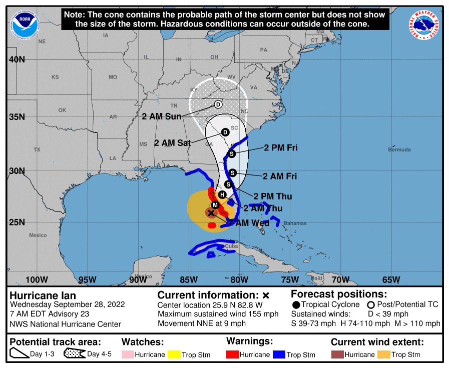
Hurricane Ian has strengthened into a Category 4 storm as it approaches the west coast of Florida.
As of 8 a.m. on Wednesday, the National Hurricane Center reports that Hurricane Ian has reached maximum sustained winds of 155 mph, with higher gusts. Ian is currently classified as Category 4, and the storm is just below Category 5 strength (157 mph or higher).
Ian is currently around 55 miles west of Naples and approximately 60 miles southwest of Punta Gorda. The storm is moving to the north-northeast at a speed of 10 mph.

The NHC states that Ian is expected to slow down today, which will then be followed by a turn toward the north on Thursday. On this track, the center of Ian is expected to move onshore later this morning or early in the afternoon.
Ian is forecast to make landfall on the west coast of Florida as a catastrophic hurricane, and weakening is expected after the storm makes landfall. Hurricane-force winds extend outward up to 40 miles from the center, and tropical storm-force winds extend outward up to 175 miles.
The center of Ian is forecast to move over central Florida tonight and into Thursday morning, and the storm is expected to emerge over the western Atlantic by late Thursday, according to the NHC.
As it stands, the NHC predicts that central and northeast Florida may receive anywhere from 12 to 24 inches of rainfall as a result of the storm. Widespread, catastrophic flash, urban, and river flooding is expected across central and west Florida.
The NHC states that tornadoes will be possible today and throughout the evening across central and south Florida.
In anticipation of the approaching storm, Marion County has announced multiple government office and service closures.
